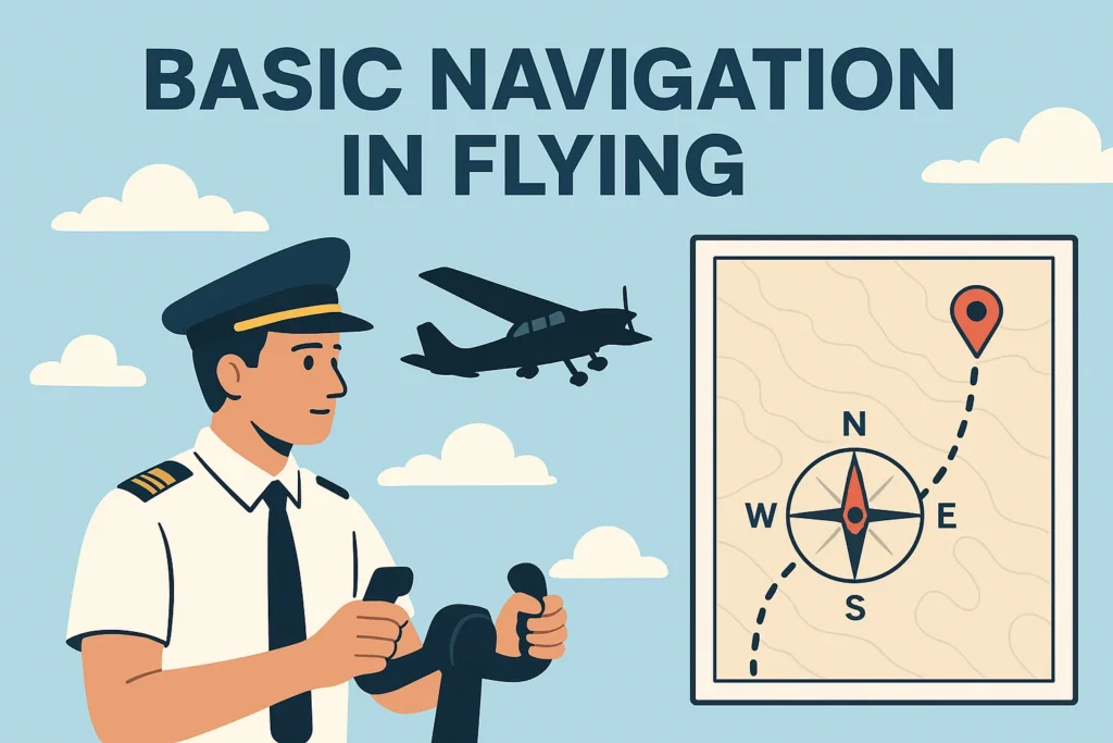
Navigation in aviation refers to the science and skill of planning, recording, and controlling the movement of an aircraft from one point to another. While early aviators relied heavily on visual landmarks and compasses, modern flight depends on sophisticated systems such as GPS (Global Positioning System), VOR (VHF Omnidirectional Range), NDB (Non-Directional Beacon), and INS (Inertial Navigation Systems).
Objectives of Navigation in Aviation
The key objectives of navigation are:
- To ensure aircraft safety by avoiding restricted areas, terrain, and other traffic.
- To provide efficient routing that minimizes fuel burn and flight time.
- To comply with air traffic control (ATC) procedures and international regulations.
- To maintain situational awareness during all phases of flight.
Basic Types of Navigation
- Dead Reckoning (DR) Navigation – Calculating position using heading, time, and speed without outside references.
- Pilotage – Using visible landmarks (common in VFR flights).
- Radio Navigation – Using ground-based beacons like VOR, NDB, and ILS (Instrument Landing System).
- Satellite Navigation (GNSS/GPS) – Provides accurate real-time positioning worldwide.
- Inertial Navigation (INS/IRS) – Uses gyroscopes and accelerometers for navigation without external input.
Jeppesen Charts: The Pilot’s Guide to Navigation
One of the most important tools for professional pilots is the Jeppesen chart system, developed by Elrey B. Jeppesen in the 1930s. Today, Jeppesen charts (or “Jepps”) are a standard in the airline industry, offering detailed, standardized, and updated navigation information for every phase of flight.
Why Jeppesen Charts Are Essential
- Standardization: Unlike government-issued charts, Jeppesen charts follow a uniform design worldwide.
- Accuracy: Charts are updated frequently to reflect the latest changes in airspace, procedures, and airport layouts.
- Detail: Include everything from airway routing to approach minima, SID/STAR procedures, and airport diagrams.
Types of Jeppesen Charts
- Enroute Charts – Show high- and low-altitude airways, navigation aids, and reporting points.
- SID Charts (Standard Instrument Departure) – Provide structured departure routes from airports.
- STAR Charts (Standard Terminal Arrival Routes) – Define arrival procedures into airports.
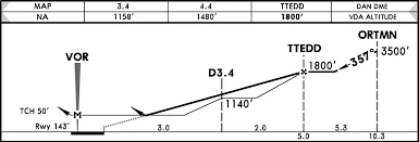
- Approach Charts (IAPs – Instrument Approach Procedures) – Contain instructions for precision and non-precision approaches.
- Airport Charts – Show airport layouts, taxiways, runways, and parking areas.
Understanding SID (Standard Instrument Departure)
A SID is a pre-planned IFR (Instrument Flight Rules) departure procedure published to simplify clearance delivery and reduce pilot/ATC workload.
Purpose of SIDs
- Provides safe obstacle clearance after takeoff.
- Standardizes departure routes to manage air traffic flow.
- Helps ATC sequence aircraft departing from busy airports.
How Pilots Use SIDs
- Pilots receive SID clearance in their IFR clearance before departure.
- The SID chart shows initial climb gradients, waypoints, transition points, and communication frequencies.
- SIDs may be RNAV-based (using GPS) or conventional (using VOR/NDB).
Example: The “CLN 9R SID” at London Heathrow provides a structured routing for eastbound departures via Clacton VOR.
Understanding STAR (Standard Terminal Arrival Route)
A STAR is the opposite of a SID—it provides a structured route for aircraft approaching an airport.
Purpose of STARs
- Organizes arriving traffic efficiently.
- Provides predictable descent and sequencing for ATC.
- Ensures safe terrain clearance and smooth integration into instrument approach procedures.
STAR Usage
- Pilots follow STARs from enroute airways down to approach transition points.
- Like SIDs, STARs can be RNAV-based or conventional.
- A STAR typically ends at an Initial Approach Fix (IAF) for instrument approaches.
Example: The “CPT 3F STAR” at London Heathrow guides arrivals from the south via the Compton VOR.
Routing in Aviation
Routing refers to the path an aircraft takes between departure and arrival airports. Routes are designed to balance safety, efficiency, and airspace management.
Types of Routing
- Airway Routing: Most IFR flights follow published airways defined by VORs and waypoints.
- Direct Routing: ATC may clear flights directly between waypoints, especially in low-traffic areas.
- RNAV Routing: Uses GPS to create flexible and fuel-efficient direct routes.
- Oceanic Routing: For transoceanic flights, aircraft follow tracks such as the North Atlantic Tracks (NATs).
Routing in Flight Planning
- Routes are chosen based on weather, winds aloft, airspace restrictions, and ATC requirements.
- Flight management systems (FMS) use routing data from Jeppesen databases to load waypoints automatically.
Airport Charts: Navigating the Ground
An airport chart is one of the most crucial references for pilots during taxi, takeoff, and landing operations.
Information on Airport Charts
- Runway lengths, widths, and surface types
- Taxiways and apron layouts
- Hot spots (areas with a risk of runway incursions)
- Communication frequencies (ATIS, Ground, Tower, Clearance Delivery)
- ILS critical areas and holding positions
Importance of Airport Charts
- Prevents runway incursions by providing precise taxi guidance.
- Helps pilots locate gates, taxiways, and holding points at unfamiliar airports.
- Used by both pilots and ATC for ground traffic coordination.
Example: The Jeppesen airport chart for JFK includes detailed taxiway designations, runway operations, and ramp areas.
Integrating Navigation with Modern Technology
While the fundamentals of SIDs, STARs, and airport charts remain the same, modern technology has improved accessibility and accuracy:
- Electronic Flight Bags (EFBs): Tablets used by pilots with digital Jeppesen charts.
- GPS/GNSS Navigation: Ensures precision routing globally.
- Performance-Based Navigation (PBN): RNAV and RNP procedures allow more efficient routing.
- ADS-B (Automatic Dependent Surveillance-Broadcast): Enhances situational awareness and reduces separation minima.
Common Challenges in Navigation and Chart Use
Even with advanced systems, pilots face challenges such as:
- Chart clutter: Some Jeppesen charts are dense with information.
- Procedure changes: Frequent updates require pilots to stay current.
- Navigation database errors: Rare but possible if data isn’t updated.
- High workload: Busy airspace requires balancing navigation with ATC communication and aircraft control.
Final words
Navigation is at the heart of aviation safety and efficiency. From the earliest forms of pilotage and dead reckoning to today’s GPS-based RNAV systems, pilots rely on standardized tools and procedures to move across the skies safely.
Jeppesen charts remain the global standard for professional flight operations, offering detailed instructions for SIDs, STARs, routing, and airport layouts. For students and aviation enthusiasts, mastering these basics is essential for progressing in the world of aviation.
Whether you are studying for your pilot exams or simply passionate about aviation, understanding the fundamentals of navigation and Jeppesen charts provides the key to unlocking the complex but fascinating world of air travel.
https://shorturl.fm/Woy8c
https://shorturl.fm/GvMbI
https://shorturl.fm/g6J0A
https://shorturl.fm/hyQYm
Your style is so unique compared to many other people. Thank you for publishing when you have the opportunity,Guess I will just make this bookmarked.